

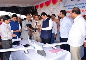
The Survey of India, the national mapping agency under the Ministry of Science & Technology, has signed an MoU with the Department of Revenue and Land Records, Government of Maharashtra, to undertake large-scale mapping of village Gaothan (Aabadi) areas in the state using drones.
The Chief Minister of Maharashtra, Shri Devendra Fadnavis, inaugurated the drone-based mapping project at Nimgaon Korhale in Ahmednagar district on 31st July 2019. The Minister of Rural Development, Women and Child Welfare, Smt. Pankaja Gopinath Munde; Surveyor General of India Lt Gen Girish Kumar, VSM; and senior officials from the Revenue and Rural Development departments were also present at the launch.
The project is being implemented by the Survey of India for the Department of Revenue and Land Records, Government of Maharashtra, using professional survey-grade drones to cover more than 40,000 village Gaothan areas across the state.
These village areas, which were not previously surveyed, will be mapped at a 1:500 scale covering all land parcels to create accurate revenue maps and a GIS database. The drone survey will help accurately determine village boundaries, canals, canal limits, and roads.
A detailed presentation on the project was also made during the National Workshop and Conference of Sarpanch and Upsarpanch organized by the Department of Rural Development, Government of Maharashtra and the All India Sarpanch Association in Shirdi, Ahmednagar. The event was attended by thousands of Sarpanchs, Upsarpanchs, farmers, and several public representatives, under the guidance of the Chief Minister and other senior state leaders.

